Daily UV index and UV dose data
in yearly netCDF files

Clear-sky UV index: erythemal
Daily UV dose: erythemal | vitamin-D | DNA-damage
Daily UV index and UV dose data
|

|
|
Archives of maps and data files of individual days:
Clear-sky UV index: erythemal Daily UV dose: erythemal | vitamin-D | DNA-damage |
The standard UV data archive − accessible through the links above −
provides maps and links to HDF-4 data files for individual days.This page provides the daily UV data gathered together
in yearly netCDF files as well as climatologies.
select year data coverage data set prefix world | europe
world | europe
world | europe
world | europe
clear-sky erythemal UV index & ozone field
clear-sky & cloud-modified erythemal UV dose
clear-sky & cloud-modified vitamin-D UV dose
clear-sky & cloud-modified DNA-damage UV doseuvief
uvdec
uvdvc
uvddcNotes

- Data coverage comes in two versions: the full World or Europe
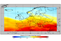
- Europe is longitude = [−25°:+45°], latitude = [+30°:+70°]; see sample on the right
- World data files are 0.9 - 1.2 GB, Europe data files are 60 - 100 MB
- Clear-sky UV and ozone data is available for the full World
as of 1 July 2002- Cloud-modified UV dose data is available for the area covered
by the MSG satellites as of 22 January 2004 and in use up to
the end of 2025; as of 1 January 2026 the cloud data comes
from the MTG satellites
- Climatology is an average for each day over 17 years: 2004 - 2020
(wherein leapday 29 Feb. is skipped)- Climatology data files are larger than regular files:
World data files are 1.9 - 3.0 GB, Europe data files are 130 - 190 MB
- Data files for the current year are updated manually on an
irregular basis and may therefore be incomplete
Last data added: 31 January 2026
- History:
19 July 2022 = update of all files to correct 'date_month' dataset attributes
27 Sep 2021 = public release of the netCDF files
Data files can also be downloaded with a script, for example, using wget:wget https://www.temis.nl/uvradiation/v2.0/nc/2020/uvdvc2020_world.nc wget https://www.temis.nl/uvradiation/v2.0/nc/2018/uvddc2018_europe.nc wget https://www.temis.nl/uvradiation/v2.0/nc/clim/uviefclim_world.ncwhere the first 5 characters of the data file name (such asuvdvc) is the prefix
listed in the last column of the table above, andclimindicates climatologies.
UV data timeseries at a given location
From these files it is relatively easy to extract time series for a given location
-- so-called overpass data -- e.g. by starting from this sample Python tool.You may, however, want to check first whether we are already extracting and
daily updating overpass data for your location -- see this page.
General information
![]() last modified: 11 February 2026
last modified: 11 February 2026
Contact form
Copyright © KNMI / TEMIS